
Overview of Wolayita Zone:
Located in the South Ethiopia Regional State, Wolayita is a long-standing zone that serves as the seat for the region’s administrative clusters. Structurally, the zone is organized into 16 districts (Woredas) and 10 town administrations.
- Geography and Climate
- Location: Situated 310 km from Addis Ababa via Butajira, and 380 km via Shashemene.
- Capital: The administrative center of the zone is Sodo city.
- Boundaries: Bordered by Gamo Zone to the south, Dawro Zone to the west, Kembata Zone to the northwest, Hadiya Zone to the north, the Oromia Region to the northeast, and the Sidama Region to the east.
- Topography: Features a captivating landscape characterized by a mix of mountainous terrains, high-altitude highlands, and deep valleys.
- Climate: Predominantly Woyina Dega (sub-tropical/temperate), making it highly favorable for agriculture and human settlement.
- Demographics and Language
- Ethnicity: The zone is primarily the homeland of the Wolayita people.
- Language: The native language is Wolaitattuwa (Wolayita). It belongs to the Omotic language family and stands as one of the most widely spoken languages within the North Omotic branch. Amharic is also widely spoken as a secondary language.
- Social Values: The community is highly regarded for its strong work ethic, exceptional hospitality, and industrious culture.
- Historical Background
- Royal Dynasties: Historically, Wolayita was ruled by two powerful and influential royal dynasties: the “Wolayita-Malla” and the “Tigre” dynasties.
- Kingship (Kawo): Monarchs held the title of Kawo. The Kawo served as the ultimate political, judicial, and military leader, while also commanding immense spiritual reverence and moral authority among the people.
- Governance: Artifacts in the local transition museum demonstrate that Wolayita possessed a well-structured, indigenous system of justice and social administration long before the introduction of modern governance.
- Gifata: The Wolayita New Year Festival
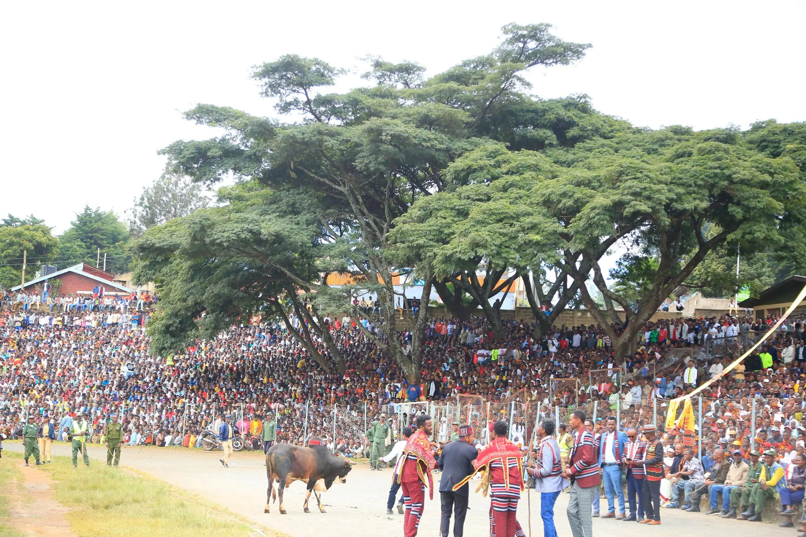
Gifata is the traditional New Year festival of the Wolayita people. Celebrating a transition of seasons, it has achieved global recognition and is inscribed by UNESCO as an Intangible Cultural Heritage of Humanity. The word Gifata signifies leaving the old year behind to welcome the new. It marks the end of the dark, foggy rainy season and ushers in the season of harvest, light, and joy.
Cultural Rituals & Celebrations
- Community Reconciliation: Before the festival begins, individuals in conflict resolve their grievances and reconcile to start the year in absolute peace.
- Preparations: Ahead of the festival days, houses are renovated and cleaned. Traditional foods and beverages primarily derived from Enset (false banana) are meticulously prepared.
- Dances and Games: Youths and adults dress in vibrant, colorful traditional attire to perform unique collective Gifata cultural dances and celebratory games.
Social Significance
- Unity and Love: Gifata acts as a homecoming event where Wolayita natives living in various regions return to their ancestral land to reunite with families and renew community bonds.
- Thanksgiving: It is a sacred time to offer gratitude to the Creator (Tossa) for safely guiding the community through the harsh winter and granting light and a bountiful spring harvest.
Culinary Tradition
- Mucho: The signature traditional delicacy of the festival, freshly prepared using high-quality Kocho (processed Enset), prime beef, and pure clarified spiced butter.
Summary: Gifata is a living heritage that beautifully reflects the identity, deep-rooted history, and ancient astronomical knowledge of the Wolayita people.
- Economy and Agriculture
Agriculture and commerce form the twin pillars of the Wolayita economy.
- Food Security Crops: Enset is the bedrock of local food security. Additionally, maize, wheat, Teff, cassava, various pulses, and “Boyna” (the Wolayita potato) are extensively cultivated.
- Cash Crops: High-quality ginger, coffee, various spices, and a rich assortment of fruits and vegetables are produced heavily for domestic and commercial markets.
- Commerce: The capital, Wolayita Sodo, serves as a vital commercial and transportation hub in Southern Ethiopia, driving high-volume trade activities.
- Education and Health
- Wolayita Sodo University: A premier public higher education institution in the zone that contributes significantly to national agricultural and healthcare research.
- Wolayita Lika School: A highly prestigious residential school of excellence, renowned nationally for nurturing top-tier, high-achieving competitive students.
- Major Tourist Attractions
- Mount Damota: Standing at 2,950 meters, this historic mountain overlooks Sodo like a crown; it is an ancient seat of kings rich in biodiversity and historical relics.
- Ajora Waterfalls: A breathtaking pair of twin waterfalls formed by the Ajancho (210m) and Soke (170m) rivers, unrivaled in East Africa.
- Mochena Borago Cave: An ancient rock shelter at the foot of Mt. Damota where archaeological evidence proves human habitation dating back 58,000 to 70,000 years.
- God’s Bridge (Tossa Zarpheya): A massive, awe-inspiring natural stone bridge across the Manisa River used safely by the community for generations.
- Banbala Suspension Bridge: A striking man-made engineering marvel spanning 115 meters long over an 80-meter drop, surrounded by a lush, breezy ecosystem.
- Arujia Caves: Ancient defensive subterranean networks carved into rugged terrain by early clans, capable of housing up to 500 people and 200 horses.
- Humbo-Abala Carbon Project Forest: A 2,800-hectare restored forest that ranks as Africa’s largest and the world’s second-largest registered carbon-sequestration project.
- Wolayita Museum: A cultural repository housing rare ethnographic artifacts including Marchua (ancient iron currency), Sheta (clay thermos), and Buuda (ceremonial horn vessels).
Conclusion
The Wolayita Zone stands as an enchanting destination where natural wonders, ancient history, and vibrant living cultural values seamlessly intertwine to drive rapid modern development.